

The Project
As the City’s prime consultant for nearly three decades, RK&K has provided the design, development, and specifications for all aspects of the City’s combined stormwater/wastewater collection system GIS data layers. RK&K’s design for the GIS balances facilities management and maintenance requirements with the technical specifications needed for hydraulic and combined sewer overflow (CSO) studies.
RK&K’s services span the full spectrum of GIS implementation, including:
- GIS database design within the Esri ArcSDE environments
- Detailed conversion methodology documentation
- Field data collection methodologies and documentation
- GIS mapping application environment design and implementation
- Feature naming conventions
- GIS dataset development and quality control
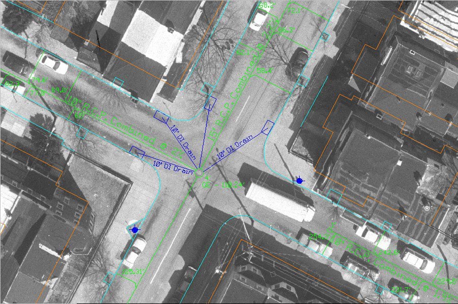
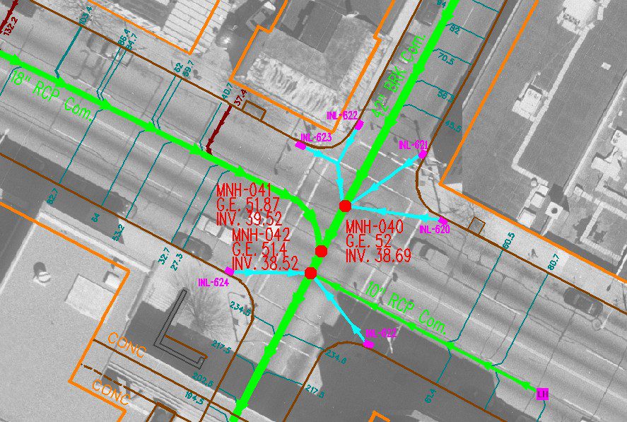
- RK&K developed the initial design for the GIS database, which encompasses 19 distinct collection system features, 134 subtypes, and numerous related tables storing documents and CCTV inspection records.
To validate and enhance system accuracy, our field teams conducted extensive surveys across the City, performing manhole inspections to precisely document feature coordinates, inverts, materials, sizes, flow direction, and other critical properties.
RK&K migrated the City of Wilmington’s combined stormwater/wastewater collection system geodatabase containing over 86,000 features and more than 108,000 related documents to the Esri Local Government Model using a custom ETL developed in Safe Software’s Feature Manipulation Engine. RK&K is currently updating the GIS data based on recent system upgrades, maintenance activities, CCTV videos and Development Plan reviews.
As the City’s prime consultant for nearly three decades, RK&K has provided the design, development, and specifications for all aspects of the City’s combined stormwater/wastewater collection system GIS data layers. RK&K’s design for the GIS balances facilities management and maintenance requirements with the technical specifications needed for hydraulic and combined sewer overflow (CSO) studies.
RK&K’s services span the full spectrum of GIS implementation, including:
- GIS database design within the Esri ArcSDE environments
- Detailed conversion methodology documentation
- Field data collection methodologies and documentation
- GIS mapping application environment design and implementation
- Feature naming conventions
- GIS dataset development and quality control
- RK&K developed the initial design for the GIS database, which encompasses 19 distinct collection system features, 134 subtypes, and numerous related tables storing documents and CCTV inspection records.
To validate and enhance system accuracy, our field teams conducted extensive surveys across the City, performing manhole inspections to precisely document feature coordinates, inverts, materials, sizes, flow direction, and other critical properties.
RK&K migrated the City of Wilmington’s combined stormwater/wastewater collection system geodatabase containing over 86,000 features and more than 108,000 related documents to the Esri Local Government Model using a custom ETL developed in Safe Software’s Feature Manipulation Engine. RK&K is currently updating the GIS data based on recent system upgrades, maintenance activities, CCTV videos and Development Plan reviews.
